These are a selection of pictures that I have taken on various trips to the Da Xue Shan Forest Recreation Area (大雪山森林遊樂區). Located in Nantou County (南投縣), it's a surprisingly short drive from Taichung (台中). The road up the mountain begins in Dongshi (東勢) and then ascends for 50 kilometres. This is as far as it is possible to go by motor vehicle, (at least without being fined!), although it is possible to hike beyond this point.

The road up this mountain was closed for a long time after a series of particularly severe typhoons.The bridge you see in this picture was built to allow temporary access to work crews. The security guard allowed me to cross this bridge on my bike and I literally had the whole mountain to myself. As you can see, since then, another landslide has put the bridge out of action.

This is the new bridge that will hopefully survive future typhoons!

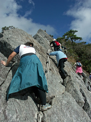
There are many challenging hiking trails all over this mountain. These pictures were taken on the trail to Yuan Zui Shan (鳶嘴山), which I attempted with my wife. Some parts of the trail are quite steep, so ropes have been placed to make life easier.

My wife reluctantly begins the ascent.


After much effort we got to the top. The views of the Central Mountain Range (中央山脈) are breathtaking on a clear day.


My wife takes a well-deserved break at the summit of Yuan Zui Shan (鳶嘴山).


After enjoying the scenery for a while, we made our way down the mountain via a different route.

My wife didn't enjoy this part!


This picture is looking back at Yuan Zui Shan (鳶嘴山). You can see the ridge we had just climbed down.

The trail then descends into a forest. Usually by early afternoon, the mountain is enshrouded in mist.


Equally spectacular views can be enjoyed further up the mountain without the need for such a long hike. These pictures were taken from a viewing platform, which is less than a twenty-minute walk from the road. The platform sits at 2600 metres and provides a magmificent 360 degree vista.


My parents, who visited Taiwan last summer.


5 comments:
Beautiful pictures. Too bad I never been to any of those places. Shouldn't security be more strict than just climbing on your own?
Actually, there were lots of other people on the mountain at the same time, so if there'd been a problem, help would have been close at hand. However, for the really dangerous hikes in Taiwan it's necessary to first get a permit from the police or risk being heavily fined.
wow!!
lots of beautiful pic again :)
Taiwan is so beautiful,
and your photo skill is outstanding !!!
btw, how are you recently?
do you have any plan for this summer vacation?
BY Emily :D
Hi, your pics have inspired me to go hiking up there this weekend... Can you tell me how to get there from Taichung? Thanks!
Hi Jonathan,
I'm sorry, but I've only just seen this message. I don't really use this blog anymore. Nowadays, I post my photos on this website:
www.touringtaiwan.smugmug.com
Here's a link for the route on google maps from Sogo:
http://goo.gl/maps/t5Qv0
On the road up from Dongshi, there are lots of hikes. The one with the ropes starts after you pass the narrow tunnel at about the 27km mark on the road. There's a clear sign. After the 35km mark, you enter the forest recreation area where they will give you a map of the trails when you pay the entrance fee. If you have anymore questions, you can email me:
andytown2001@yahoo.co.uk
Cheers,
Andy
Post a Comment